Instructor:
Course: Reconceptualizing the Urban: Berlin as Laboratory
Students: Michael Keller
“The cities and the installations are forced to wander, and we must first of all analyze carefully this wandering before building in grand style and with great expectations new inhabitable spaces.” – Martin Wagner, Das Wachsende Haus
This project investigates the interrelationships across landscape and industry, recreation, and resource extraction, which continue to characterize the Berlin and Brandenburg region as city-landscape. Particular attention is paid to the industrialization and urbanization of the region from the late 19th century and the planning efforts of Weimar-era building director Martin Wagner, notably his General Open Space Plan of 1929.
While the planning works of Wagner constitute an awareness and to a degree an incorporation of ideas from a wider planning discourse, they also reveal a growing awareness of the territorial scale of industrial urbanization particular to Berlin and the need to develop new theoretical frameworks to address a growing disassociation between settlement and workspace. The General Open Space Plan of 1929 and its coordination of ‘unbuilt’ spaces comprising recreational and resource conservation value is a salient example of but one technique by which the modernist planner seeks to address this problematique.
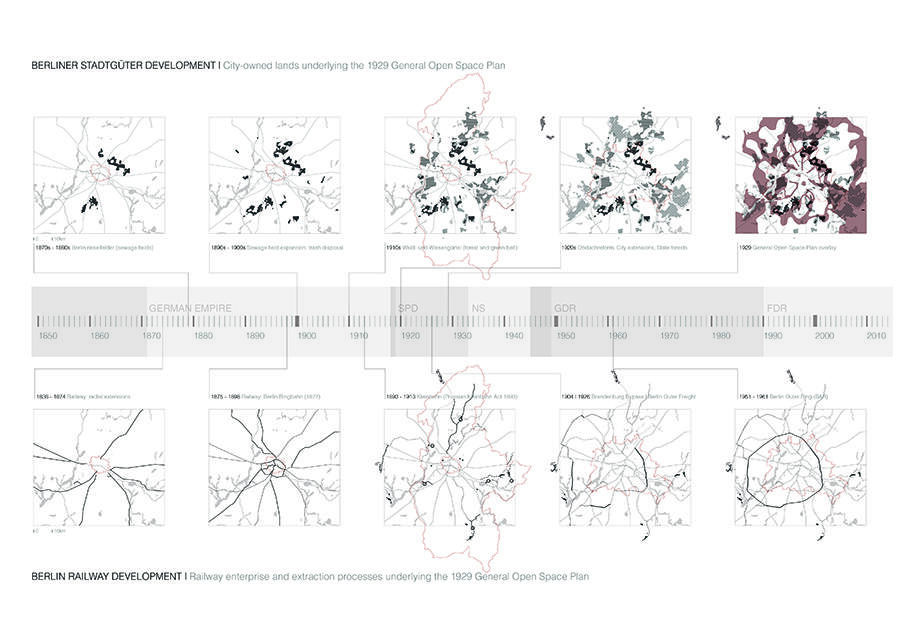
The research postulates that the development of the railways and the purchases of agricultural and forested lands by the city within and beyond its administrative boundaries were instrumental to realizing and organizing the metabolic functions of an expanding Berlin in the Weimar period, and that these spaces, to a great degree, constitute the “figure” of Wagner’s open space plan. As such, the spatial characteristics of these grounds and the networks of their continuously evolving functions continue to serve as important frames through which we can understand a city in transition, a city characterized today by imminent population growth amid increased inner-city property speculation, and by a periphery that’s actively being designed from agricultural and sewage uses to accommodate new landscapes of local energy production, resource conservation, recreation and development.
The investigation is organized into three sections concerning, respectively, the industrial context of planning, the plan itself, and four sites representative of the key relationships being explored. The first section begins with a brief account of Berlin’s industrial and political context, accompanied by a pair of map sequences that explore the parallel developments of the railways and the Stadtgüter, or city goods, as key constituents underlying the 1929 plan. The second section focuses on the 1929 plan itself as well as the text accompanying its publication, in an effort to understand the means through which Wagner develops the notion of the city-landscape in his attempt to address the aforementioned problematique. This is paired with a series of map overlays that relate the open space plan to the railways, the city goods, recreational destinations and a contemporary landscape of conservation and energy production. The third section interrogates four particular sites as representative of the wider interrelationships across landscape and industry, recreation, and resource extraction, which continue to characterize the Berlin and Brandenburg region as city-landscape.
The research makes use of primary textual resources available at Harvard University’s Loeb Library, notably through the Wagner Collection, as well as historic maps, postcards, and photographs. Attention to the particular sites reveals a deep historical resonance in the relationships across recreation and resource extraction and conservation, relationships evident today in the Regionalparks Brandenburg und Berlin, a coordinated but flexible planning strategy of eight loosely-defined landscape regions across the Berlin and Brandenburg administrative areas. The intention of the research is not only to shed light on the trajectory of planning in Weimar Berlin, a time when the social aspects of modernism in architecture, landscape and planning were highly evident, but to provide a historical and theoretical contextualization through which contemporary transitional processes and conditions of urbanization across Berlin and Brandenburg may be newly conceptualized.


