Instructor:
Course: Reconceptualizing the Urban: Berlin as Laboratory
Students: Adam Himes
Since 1961, the Turkish community has had a significant presence in the Berlin neighborhood of Kreuzberg, where the first Gastarbeiter, or “guest workers,” and their families settled during the labor import program between Turkey and West Germany. Densely built up with little open space, bounded on two sides by the Berlin Wall, and plagued by vacancies from the threat (and implementation) of urban renewal, the neighborhood had fallen into disrepair, yet its resultant cheap rents made it ideal for the Gastarbeiter and subsequent Turkish migrants. Since that time, there has been a close relationship between the built environment of Kreuzberg and the political status of the Turkish community. From victims of destructive urban renewal programs, to sought-after constituents in the Internationale Bauausstellung (IBA) 1984/87, to present-day citizens, this project traces how increasing political recognition and acceptance of the community has engendered greater agency within the Turkish community to express itself within the built fabric of the city. Whether in the limited form of shop signs or satellite dishes, or more significant interventions such as the construction of mosques or, in 2014, the opening of a branch campus for an İstanbul-based university, the increasing permanence of the Turkish community is evident, suggesting that Berlin will need to assimilate to them as much as they will need to further integrate with the city.
The Images:
01 – This timeline lists important political events within the history of the Turkish community in Berlin and Germany at large. Though correlation should not be confused with causation, the 1984/87 International Building Exhibition (IBA) marks a shift in Germany’s political attitude toward its Turkish community from marginalization to increasing integration. The successor entity to IBA-Altbau, STERN completed the “careful urban renewal” of Kreuzberg in the early 1990s.
02 – Hobrecht_realized open space 1940 – Of the public spaces proposed by the Hobrecht Plan, only a handful were ever realized (those in red; those in gray were unrealized). Victoria Park, the large space highlighted in the southeast (bottom left), was not part of the Hobrecht Plan, but serves to more accurately illustrate the amount of open space in Kreuzberg in 1940, the year this map depicts.
03 Berlin Wall & Stadtautobahn Expansion – Of the buildings destroyed (dark red) or damaged (middle red) by the Allied bombings of Kreuzberg (light red), most heavy damage is isolated to the historical Friedrichstadt area in the northwest (top right). Only minimally affected areas would come to be inhabited by the Turkish immigrant community. The Berlin Wall (in black) bounded Kreuzberg on the north (top) and east (right). The proposed Stadtautobahn extension would have struck an east-west motorway through historical Friedrichstadt and much of eastern Kreuzberg and a north-south route along the path of the old Luisenstadt canal. Each would have required extensive demolition, had they been realized.
04 – Extensive demolition of Kreuzberg’s dense urban fabric was required to make way for the Neues Kreuzberger Zentrum and other modern housing blocks at Kottbusser Tor.
05 – This plan shows the proliferation of Turkish-language signs around Kottbusser Tor cca. 2009, with those directly attached to the Neue Kreuzberger Zentrum (and the complex itself) highlighted in red.
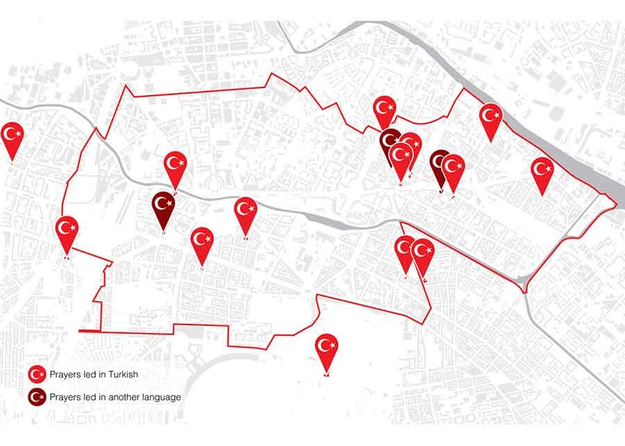
06 – This map shows the distribution of Muslim prayer spaces in and around Kreuzberg. Those with prayers led in Turkish are marked in red and those led in other languages in maroon.
07 – These diagrammatic plans of mosques in Kreuzberg show how they echo the traditional spatial progression of mosques, here represented by the neo-Ottoman Şehitlik Mosque (upper left).


